At this point I must say a few words about the gentleman dock master, George. He is the "face" of the Errol Flynn Marina in Port Antonio, Jamaica. He is the man that makes everything happen and he does it with a smile. He greets you at dockside when you first arrive and arranges for anything you need to get done or found out about. He is wonderful. We had questions about our planned stop in Port Morant so he suggested that we meet his father because George, Sr. had experience as a pilot all around Jamaica and beyond.
George, Sr came to the marina and we moved to a table near the pool to discuss sailing along the North, East and South coasts and anchoring in Port Morant.
 |
| Jay, Barb, George Sr, Kathy, Ron and Dan |
We (S/V Jupiter's Smile, S/V Sea Star and S/V Dawn Trader) departed the harbor in Port Antonio, resigned to motor sailing several miles directly into the seas and light wind, rounding the point and then sailing to the south side of Jamaica covering 25 nautical miles to Port Morant to overnight at anchor before heading out to Bajo Nuevo.
We pulled up the anchor at dawn and ran down the wide channel to the sea and sailed southwest just beyond the Kingston ship traffic. Bajo Nuevo is a spit of coral reef poking out of six thousand feet of Caribbean Sea about 215 nautical miles away from Port Morant. We had a good sail through the day and night approaching Bajo Nuevo from the north with good light in the early afternoon.
 |
| Dawn Trader at dawn |
Sea Star had been here before and we used their way points to a good anchorage.
Bajo Nuevo 125 nm NE of Serrana, 180 nm SW of Port Morant, Jamaica
1 N15degrees 54.79’, W 078degrees39.76’
2 N15degrees 53.88’, W 078degrees40.52’
3 N15degrees 52.98’, W 078degrees39.28’ Sandy patch
4 N15degrees 52.90’, W 078degrees38.73’
As we approached we could not see land, but could detect a wreck on RADAR that marked the eastern end of the reef. We anchored next to Sea Star and waited for Dawn Trader's arrival. We did not leave the boats as we did not want to lower our dinghies for the short time that we planned to be there. We saw that another boat was seemingly anchored very close to the sand spit near the transmitter tower, but we saw no dinghy, activity or signs of life. The next morning, after a good night's sleep, we went on our way toward the Serrana Bank 140 nm away.
There was only slightly less wind, so we had another good day and night of sailing to the southwest and approached the Serrana Bank in the late morning.
Serrana 47 nm N of Roncador
1n N14o 20.00’, W 080o08.10’ Approaching from the North along the Eastern tip
2 N14o 20.56’, W 080o14.08’ Approaching from the South this is your first waypoint
3 N14o 20.80’, W 080o14.05’
4 N14o 21.14’, W 080o13.96’
5 N14o 21.26’, W 080o13.84’ It gets thin but not into single digits
6 N14o 21.33’, W 080o13.79’
7 N14o 21.40’, W 080o13.74’
8 N14o 21.52’, W 080o13.64’
9 N14o 21.80’, W 080o13.28’
10 N14o 21.97’, W 080o13.25’
We saw several motor vessels fishing the banks and saw the sea breaking on the extensive reef. We determined that the electronic charts were of little value and depended on the information shared by Mike and Gloria of Windfree, the sketch charts from a research project, our eyes and our depth sounder.

We lined ourselves up between Narrow and South cays and passed to the right of Little Cay and into shallow (but not too shallow) water, where we could find a good spot to anchor. Sea Star led the way and we followed right on their stern. There was no drama since the sun was high and water was clear. We could spot the coral heads and determined their depths to be no threat or we avoided those that seemed shallow. We anchored in about 20 ft of water in a large sandy spot between grass. We were hailed on the radio by a Colombian Coast Guard vessel and I answered. They took some information from us over the radio and then told us to be prepared to be boarded for inspection. Dan and Cathy had wasted no time in launching their dinghy and were all ready to explore the coral heads nearby. I told them about the radio call. We had seen the Coast Guard vessel as we entered the reef, but we couldn't see them now so they headed out to explore. After a while, a launch approached and went to Dan and Cathy's dinghy to escort them back to Sea Star and four men clambered aboard. After about a half-hour they came to our boat and four of them came aboard. They were from the cutter, A.R.C. Quindio. Two men sat in our cockpit, two stayed in their launch and the senior officer and another seaman came below and looked at our documents. Their inspection consisted of taking digital photos of our main cabin. They spoke pretty good English and were very engaging.
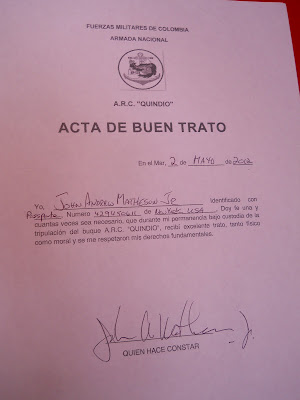
I signed a document stating that we were treated with respect and they departed to inspect Dawn Trader. Dan, Kathy, Barb and I snorkeled several spots that afternoon and found them to be interesting, but not spectacular.
 |
| Capt. Ron before before the mast ascent |
The next day, Barb and I dinghyed over to Dawn Trader to haul Ron up his mast so he could inspect his main halyard. It was showing some wear and there was concern that it would part while underway. Ron took some photos of the problem and a couple of us at anchor as well.
 |
| Jupiter's Smile and Sea Star anchored in a sandy patch |
Barb and I then dinghyed to all three of the cays we passed on our way into the reef and saw evidence of many sea turtle nests that had been recently made. We took care not to disturb them. We decided to jump in the water holding on to the dinghy and drifted along in the current wearing our snorkel gear. That proved to be a good idea as we saw a shark, many fish, interesting coral and effortlessly covered a good bit of ground. It was a good day, but we were ready to push on another 45 nautical miles to the Roncador Banks, aiming to arrive in Panama by the tenth to meet Larry, Christina and baby Dorothy.
Waypoints originally from Mike and Gloria on Windfree modified by Jay on Jupiter’s Smile.
1s N13o 32.00’, W 080o 06.00’ Approaching from the South along the Western side
1n N13o 34.50’, W 080o 05.80’ Approaching from the North along the Western side
2 N13o 33.40’, W 080o 05.13’
3 N13o 33.40’, W 080o 04.42’ requires good light - but worth it!
 |
| Roncador Cay from our anchorage |
 |
| Moonrise over the sand spit. Notice the log upon which we cleaned conch |
The forecast was for the wind to decrease in a few days and we still had 250 nautical miles to sail so, bidding a sad adieu to Sea Star, Dawn Trader accompanied us southward, toward Porvenir, Panama in the Guna Yala archipeligo. Dan and Kathy planned to head to Providencia, about 70nm to the Southwest.
I have been informed that what used to be the Kuna Indians are now the Guna Indians as of October 2011, since they removed three letters from their alphabet. One of the letters is the "K" and they replaced it with a "G". I understand that this is more in keeping with their ancestral linguistic roots.
Covering the distance thus far has been wonderful with just two overnights and three convenient and rewarding stops.


No comments:
Post a Comment